A massive storm spanning thousands of kilometres in diameter is today set to hit New Zealand, bringing alarming amounts of rain and severe wind gales.
The South Island, primarily the West Coast, will bear the brunt of the rain, parts of the North Island will also get their share.
However, the storm is set to only "brush" the country, meaning many areas will bask in hotter-than-normal temperatures, as it goes past over the next seven days, Philip Duncan of weatherwatch.co.nz said.
"The storm itself won't directly cross NZ, but it's so large in size it can't help but swipe us.
"It means pockets of severe weather, potentially in both islands for a time, but while this is definitely one of the larger storms we've seen this year it also doesn't equal an especially rough time for many parts of New Zealand," Duncan said.
"In fact, for some areas it may enhance the sunny and hot weather you've already been having lately.
/arc-anglerfish-syd-prod-nzme.s3.amazonaws.com/public/SOF3TP4UWVEWNJSHXE7BOC2FAY.png)
A graphic of the storm as it's projected to look on Wednesday, December 4. Image / weatherwatch.co.nz
"Big doesn't always mean bad, as these large weather systems tend to have very large areas of calm or what most of us would consider 'normal' weather."
However, anyone planning to be on a ship in the Southern Ocean next week would likely be in for a terrifying ordeal, with gigantic seas and hurricane force winds expected.
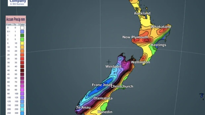
"Most impacted by rain will be the West Coast, with significant totals there which could lead to slips, flooding and road closures," Duncan said.
"Some snow on the ranges too. Winds will be strongest in the east, but especially around the mountains and Cook Strait next week.
"The low pressure will remain hugging NZ just to our south until Monday of next week and basically means a westerly flow will kick in, with rain on the West Coast, winds through central and eastern areas and remaining warmer than normal in the east and north."
/arc-anglerfish-syd-prod-nzme.s3.amazonaws.com/public/ODBZJQV2GNEOZOAU5T3RVLDKVQ.png)
The snow forecast for the 7 days from Saturday to Friday. Image / weatherwatch.co.nz
Take your Radio, Podcasts and Music with you