ZB ZB
Live now
Start time
Playing for
End time
Listen live
Listen to NAME OF STATION
Up next
Listen live on
ZB

Icy windscreens all around after frozen night across the country

Author
NZ Herald ,
Publish Date
Wed, 4 Jul 2018, 6:54AM
It is a frozen windscreen kind of morning across the country. File photo / Bevan Conley

Icy windscreens all around after frozen night across the country

Author
NZ Herald ,
Publish Date
Wed, 4 Jul 2018, 6:54AM

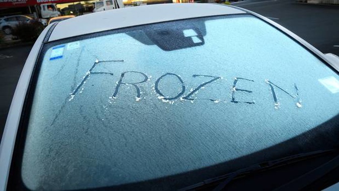
Kiwis will be waking to frosts and frozen windscreens after an icy night where temperatures plummeted into the negatives right across the country.

Even some areas of Auckland dropped below 0C, with Whenuapai Aerodrome recording -0.2C just before 6am, and many other stations sitting around 0C.

The coldest place to be this morning though was St Arnaud in the Nelson Lakes region where it got down to -6.5C.

The main centres were slightly warmer, with Timaru taking the frosty prize in the South Island on -4.2C, and Taupō in the North Island on -3.2C.

MetService meteorologist Hannah Moes said the cold temperatures were being driven by a ridge of high pressure that had formed over the country, clearing the skies and calming the winds.

Like yesterday after a cold start most places should warm up to a fine winter's day.

Some spots could see a bit of fog this morning, possibly around Taumarunui and Nelson Lakes, but it would be isolated.

"Nothing like what we have seen in the past few days," Moes said.

A series of fronts would start to impact the far south today, with some rain forecast for Southland and Fiordland, and high cloud spreading across the South Island.

Tomorrow a northwest pattern would develop in the South Island, ahead of a front arriving Friday, bringing with it a temperature rise. That same pattern would arrive in the North Island Friday.

"We are not likely to see frosts for the next few days from tonight in the South Island, and from tomorrow in the North Island," Moes said.

The ridge of high pressure would move east of the country on Friday as the front approached from the southwest.

This front was forecast to move north over the country on Saturday and Sunday, bringing rain to western areas.

Today's weather

Whangārei

Fine with southerly breezes, but some evening cloud. 15C high, 8C overnight.

Auckland

​ Fine until afternoon, then cloudy periods. Light southwesterlies. 14C high, 8C overnight.

Hamilton

Mainly fine. Morning frosts or fog. Light winds. 14C high, 1C overnight.

Tauranga

Fine with light southwesterlies. 14C high, 4C overnight.

New Plymouth Fine spells with possible morning frosts. Light winds. 14C high, 4C overnight. 

Napier Fine apart from morning and evening cloud. Light southwesterlies. 13C high, 3C overnight. 

Wellington Fine apart from some morning cloud. Light winds. 12C high, 6C overnight. 

Nelson Fine, with morning frosts. Light winds. 15C high, 1C overnight.

Christchurch Fine, with early frosts and some high cloud from afternoon. Light winds. 11C high, 1C overnight. 

Dunedin Fine with high cloud, but an evening shower or two. Light winds. 12C high, 6C overnight.

Take your Radio, Podcasts and Music with you