Swathes of water off the South Island’s West Coast are running hotter than even the balmy eastern shores of the Far North, in an extreme marine heatwave that’s already broken local records.
Typically, sea surface temperatures (SSTs) in the region would be sitting somewhere in the mid-teens at this time of year – but the latest observations showed some coastal waters were as warm as 21C to 22C.
“That is an exceptional deviation,” Niwa meteorologist Ben Noll said of the latest satellite observations.
That temperature was currently comparable only with some near-shore spots around the Auckland region and elsewhere in the upper north.
“It’s actually warmer than what you’d find off much of the white-sand beaches of the east coast of Northland.”
The wider south-west coast region, stretching down to Fiordland, had shown an average anomaly of 3.7C over the week to January 17, with some pockets registering whopping anomalies of more than 5C.
“That would be the warmest, most anomalous week on record.”
By comparison, a freak marine heatwave that engulfed New Zealand over our record-hot summer of 2017-18 pushed SSTs in the region to 3.6C above average.
That event caused cascading losses in mussel and kelp beds, drove tropical fish into colder climes and contributed to one of the biggest melt-years ever observed in New Zealand’s glaciers.
What toll this heatwave ultimately wrought on our glaciers would be clearer when scientists carried out their annual aerial survey at the end of the summer season.
It also remained to be seen what impact this event would have on marine life.
Last year, marine heatwave conditions recorded in the Fiordland region proved the most severe yet seen.
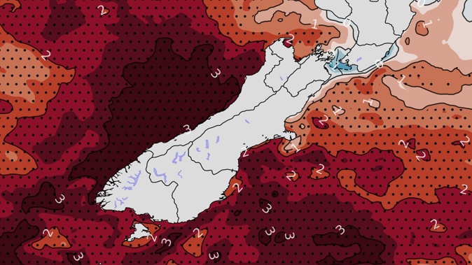
/cloudfront-ap-southeast-2.images.arcpublishing.com/nzme/7OP5QMKMXRB6DBD52U7MP3OD7Q.jpg)
This map shows current sea surface temperatures around New Zealand by anomaly (left) and temperature (right). Amid a widespread marine heatwave, sea temperatures off the South Island's West Coast are as warm as - and in some places hotter - than those observed in the upper north. Image / NOAA
Scientists were alarmed to discover millions of sea sponges there had turned from velvet-brown to bone-white – making for one of the worst bleaching events ever documented among sponge species anywhere.
Last week, MetService oceanographer Dr Joao de Souza warned of the potential for south-western waters to reach anomalies of above 6C – something never seen in New Zealand.
“By comparing the current or forecasted temperature to the average of the last 25 years for each location and day of the year, we get a picture of how much warmer than normal the oceans currently are,” he said.
“And what we are finding is disturbing. A six-degree anomaly is a whole new level compared to what we have seen before.”
Research carried out through the collaborative Moana Project had shown that, for the last couple of years, marine heatwaves have persistently impacted New Zealand coastal waters.
“The ocean has broken all records - the longest marine heatwave, which lasted just over a year in the Bay of Plenty, and now the biggest departure from normal, with 23C warm surface waters off Haast,” he said.
“This is similar temperatures to waters off Northland, and normally never happens at these latitudes.”
Otago University and Moana Project oceanographer Dr Robert Smith said the conditions were being created by a mix of climate change and other drivers, including an ongoing La Niña.
“A blocking high pressure system with light winds in the area is leading to reduced vertical ocean mixing and reduced heat loss from the ocean, triggering the marine heatwave,” he explained.
“This is exacerbated by warming in the eastern Tasman Sea, which is currently more than 2C warmer than normal at depths of 100m to 400m.
“These warm underlying conditions makes it easier for the surface ocean to tip over into marine heatwave conditions.”
Souza added that ocean temperatures didn’t vary in the way air temperatures did.
“The ocean takes a long time to heat up and cool down. Observations collected in partnership with the fishing industry show waters in Fiordland have been a lot warmer than usual for the last few days, even at depth.”
Craig Jones, a commercial fishing operator off the West Coast who worked with the Moana Project, had noticed the effects of warmer waters over the past few years.
“The patterns in fish are changing, the fish are still around but it’s not the same,” he said.
“This summer in particular we are seeing snapper and kingfish down our way more than we traditionally have. They seem to be trending south.”
Recent research has suggested that, by 2100, the 40-odd marine heatwave days we currently see in a normal year will increase to between 80 days in a low-emissions, best-case scenario – and a worst-case 170 days.
For some regions, such as the southern tip of the South Island, there was also a high chance that marine heatwaves began to last more than a year.
Cooler weekend coming
Meanwhile, MetService is reporting a freshly-formed tropical cyclone near Vanuatu and an incoming cold front should spell a cooler weekend for the country.
That change comes after a run of particularly wet weather for the Tairawhiti/Gisborne region, where one location has beaten its record for the highest January rainfall since 1937.
“Gisborne Airport has recorded 241.3 mm of rain since the start of January, surpassing its previous record of 232.8mm in January 1961,” MetService meteorologist Alwyn Bakker said. “A substantial amount of this rain fell on Tuesday 10th, when Cyclone Hale was in the vicinity.
“95.1 mm of rainfall was recorded that day at Gisborne Airport, which didn’t quite beat the station’s record for the wettest January day.
“That record was set on January 16, 1961, when the station saw 115.8 mm.” There was a little more rain on the cards today for Gisborne, but fine weather for Friday.
Further south, a series of fronts were about to make their way up the South Island overnight into Friday, bringing rain and cooler temperatures.
The fronts would weaken away as they reached the North Island on Saturday – after which another ridge of high pressure would build over the country next week.
Up in the tropics, meanwhile, the newly-named Tropical Cyclone Irene – and currently classified as a Category 2 system – was sitting just south of Vanuatu.
But Bakker said it was forecast to remain north of New Zealand, and not bring any impacts here.
“MetService will continue to monitor TC Irene, as well as the general situation over the South West Pacific.”
Take your Radio, Podcasts and Music with you