Brace yourself for serious flooding and hazardous slips is the message from forecasters as multiple weather warnings are dished out across the country for what they describe as a 'significant rain event'.
The ridge of high pressure that brought mostly calm weather over the weekend is forecast to be replaced with a complex trough of low pressure, preceded by a moist northerly flow.
The northern and western parts of the South Island were expected to take the first hit of bad weather overnight last night. MetService Meteorologist David Miller said that the area could expect more than half a metre of rainfall.
"Significant impacts can be expected, such as slips, flooding and rapidly rising rivers and streams.
"This event is exceptional not just in its accumulation amounts, but also its prolonged nature, with heavy rain expected to continue in these areas right up until Thursday evening.
"This is expected to be a significant weather event, especially for places where soil moisture content is high due to recent rain."
'Well over a month's worth of rain'
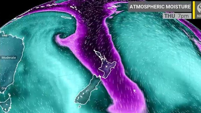
Niwa Weather experts say a long-lived atmospheric river will make landfall in the South Island today and will intensify from tomorrow through to Thursday and last throughout the weekend.
"This will lead to flooding, slips and washouts with well over a month's worth of rain, especially in the northern and western South Island."
Orange or heavy rain warnings have been issued by MetService for Buller, Tasman, Westland, Marlborough Sounds and Mt Taranaki.
North Island areas are also in line for severe weather, Metservice forecasts. The front is anticipated to travel on to the North Island later in the week, with heavy rain forecast in several areas.
Elevated areas such as Mt Taranaki, the Tararua Range and Central Plateau mountains are especially at risk of seeing impacts from heavy rain.
Additionally, a strong wind watch is currently in effect for Northland, Auckland, and Great Barrier Island due to strong north-to-northeasterly winds.
Forecasters have said that another front may deliver yet more heavy rain to the western sections of the South Island this weekend.
On a slightly more positive note, they said, the frosty temperatures observed last week will be a distant memory, with temperatures expected to be warmer than average.
Take your Radio, Podcasts and Music with you