New Zealand is set to get its first visit from an ex-tropical cyclone this season, with the South Island's West Coast and Fiordland forecast to bear Uesi's brunt on Sunday.
But little of the system's moisture was expected to go where it was needed most – in drought-stricken Auckland and Northland.
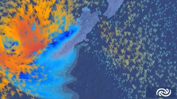
MetService meteorologist Rob Kerr said the latest models showed a "big jump" in the category 3 storm's track, which was now looking to approach Fiordland from the northwest on Sunday, before stalling and weakening offshore on Monday.
Although Uesi's low centre might not make landfall, rain bands associated with the storm should sweep over the South Island from later on Sunday, possibly bringing heavy falls and severe gales for Fiordland and parts of Westland.
Latest models show Uesi heading towards NZ. Although it won't be Tropical Cyclone by then, severe weather is still expected, particularly for southern South Island, still recovering from recent storms. https://t.co/k44wyVOt1p ^RK pic.twitter.com/gOG8qjReLF
— MetService (@MetService) February 11, 2020
"Even though the storm will no longer be characterised as a Tropical Cyclone by then, the severity of the weather associated with it will still be significant for parts of the country still recovering from recent storms."
Kerr said severe weather warnings were required, these would begin appearing on MetService's website from Friday.
He added that, as the forecast track of this system had changed significantly from yesterday, there was still a level of uncertainty associated with the exact impacts.
But at this stage there was nothing to suggest that the upper North Island would receive any of the rain.
"As the cyclone comes down to the west of the country, that ridge that is over the North Island at the moment is going to move away, and we'll start feeling a little more of an easterly flow."
That could bring warmer, moister conditions – and potentially some showers – but nothing significant enough to break a drought, he said.
WeatherWatch was advising trampers planning to walk in Fiordland and surrounding National Parks to pay close attention to the forecast from Sunday to next Wednesday - and alter plans if necessary.
While it was too early to lock in rainfall totals, preliminary estimates showed between 100mm to 150mm falling for the lower western side of the South Island – and that could potentially double, the website predicted.
It also pointed to the possibility of remnants of the system lingering and reaching the North Island at the end of next week.
"It may only be in the form of showers but Uesi will churn up currents in the atmosphere dragging down more moisture into the Tasman Sea region," WeatherWatch reported.
"There is some modelling showing showers are more likely in the end of February for the North Island."
Take your Radio, Podcasts and Music with you