A local state of emergency has been declared in the Ashburton District for seven days as torrential rain continues to lash Canterbury.
Flood levels in Canterbury have exceeded warnings "by a huge magnitude" and multiple rescue operations are taking place.
One person is awaiting rescue by helicopter to get out of a flooded area and multiple other rescue operations have already taken place.
"It's a really serious situation here in Canterbury; the rivers are breaking in multiple places," Federated Farmers president David Clark said.
Clark has been helping with rescues, including a car that has been swept out in the floods at 4.30am where fire and emergency crews couldn't get to, and a farmer being trapped in a tractor by the floodwaters.
"Key message from Federated Farmers today is that safety is paramount. Don't put your own life in danger," he said.
"We've seen multiple rescues, with machinery having to go out in deep floodwaters to rescue people."
Police were called to assist a fire crew in a rescue emergency on Walkhams Rd at 8am this morning, a police spokeswoman said.
Officials are trying to rescue a farmer who is stuck in a tree, according to a stuff.co.nz report.
"It appears one person needs assistance to get out of a flooded area," she said.
"No injuries, they're just awaiting rescue at the moment. A helicopter has been called."
A storm chaser at Canterbury Snow and Weather Watch is expecting multiple rivers to burst their banks today after the worst weather he has seen in a decade.
The region is being lashed by torrential rain, causing widespread flooding and road closures, including the stretch from Springfield to Castle Hill on SH73, the main route to the west coast.
"We're hearing that a lot of the rivers on the Canterbury Plains, which people live very close to and normally run dry, are running at the highest levels on record," Josh Oliver said.
"People are pretty concerned. Yesterday people were a bit complacent about this event, we tried to warn people and it's now coming into fruition."
Oliver said this was a "once in a lifetime event", it had been pouring for the past 24 hours, and there was still about 30 hours of the warning period to go.
"We've just heard that Mount Somers has already hit 300mm, which was the upper level of what the warning was for ... we're well on task to hit 600mm, which in New Zealand is almost unheard of, let alone in Canterbury."
Oliver, who is based in Springfield, said he was out this morning and had seen surface flooding and atrocious driving conditions.
"People really shouldn't be out unless they absolutely have to," he said.
"I normally don't get worried about a weather event, I more enjoy the thrill of going out and chasing it, but this one has gotten me worried.
He said the Heathcote River burst its banks in Christchurch last night "and it's only going to get worse from here".
"Multiple rivers would burst its banks this afternoon I would say."
The Ashburton District Council has issued a precautionary boil water notice for Methven and Mt Somers water supplies effective immediately.
Other parts of the country can expect thunderstorms as a complex low settles over New Zealand.
For only the second time ever, MetService issued a rare red warning for heavy rain for Canterbury, south of Amberley. That warning will be valid until Monday at 11am.
Civil Defence Emergency Management Canterbury is warning people to stay away from floodwaters and turn off electricity to avoid short circuits if water enters the home.
"Move livestock to paddocks that allow them to move away from floodwaters, are not at risk from landslides and are not close to power lines," it said.
"Check on neighbours and help anyone who might need assistance."
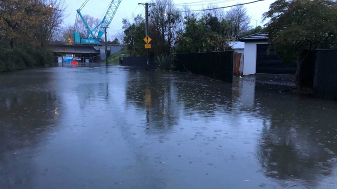
Christchurch residents were warned the deluge would most likely reach dangerous levels, and there were reports some streets were already water-logged.
This morning at 5.48am however, MetService has lifted road snowfall warnings at Arthur's Pass and Lewis Pass.
Slips have also closed roads overnight.
Tiniroto Rd in Gisborne was closed because of a large slip and will remain closed until contractors reassess the situation this morning.
Motorists are being advised to use an alternate route between Gisborne and Wairoa, such as SH2.
The stretch from Springfield to Castle Hill on SH73 also remains closed because of slips and flooding.
Weather Watch is also warning of floods as the Canterbury deluge continues and "exceptional rainfall totals" to be expected in the region.
By 8.30pm on Saturday, Methven had received 31mm of rain in about five hours, Geraldine 26mm and Darfield 20mm.
Very high river flows have been observed in Canterbury as heavy rain belts down, RNZ reports.
National Emergency Management Agency communications manager Anthony Frith said they were bracing for serious flooding in some regions. Niwa was forecasting a rapid increase in river flows across Canterbury.
The forecast deluge is expected to bring up to 400mm to the high country by late Monday morning. That is already having a downstream effect of swelling the rivers.
The Canterbury regional council's flood controller, Shaun McCracken, said the Ashburton and Hinds catchments were being closely monitored this morning.
"In particular, that's the north and south branches of the Ashburton [River]; the tributaries, the main ones being Taylor's Stream and Bowyer's Stream. They are all recording really high flows on our flow gauges.
"And if those gauges are true, they are going to be pushing the design capacity of the flood-protection scheme as it moves down the system."
McCracken said field staff were observing the rivers and his team was in touch with Civil Defence crews.
No evacuation notices were in place at this stage, but he said people should be monitoring their own situation, and if they saw something that didn't look right, "make safe decisions".
In addition to the rain in the high country, the eastern plains and coastal areas of Canterbury, including Christchurch, are forecast to receive between 100mm and 140mm of rain during the three-day deluge.
Surface flooding in Christchurch has knocked out power to hundreds of homes.
Close to 80 homes in Woolston have been without electricity since about 11.15pm on Saturday.
The lines company, Orion, said it would not be able to restore it overnight because of the flooding, but would reassess at dawn.
More than 2000 homes near Lake Ellesmere were briefly without power around 2am, but their power has been restored.
And a further 80 homes have gone dark near Springfield, as of 4am.
On Saturday, more than 1000 lightning strikes were recorded around the country in a span of just two hours.
Meteorologist Ashelee Parkes said the wild weather wasn't expected to stop soon. New Zealand is set to endure a mixed bag of weather next week as more severe rain, warm temperatures and heavy snow are set to batter the country.
"This weekend and into Monday we do have significant weather over the country," she said.
There is a "deep and very slow-moving low in the Tasman Sea" which will bring northerlies across the North Island and easterlies across the South Island.
This means more rain is on the horizon.
People on the east coast of the South Island and west coast of the country may want to pack a brolly and rain jacket as they may be lashed by more heavy rain.
But this rain will bring "slightly warmer" weather so a rain jacket may be the only extra layer need. The low moving across the country will drag some southern tropics warm air into the country, which will be a nice change from the cooler temperatures New Zealanders experienced this week.
"Some regions that are getting this rain might feel slightly muggy or humid," Parkes said.
Take your Radio, Podcasts and Music with you