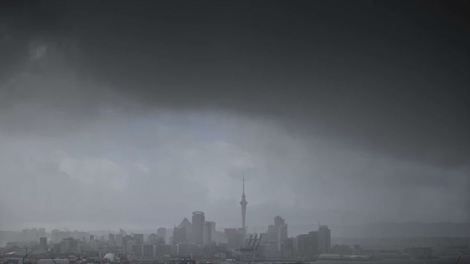
Auckland has woken up to a wild morning with sheet lightning, thunder and hail the size of squash balls.
Waimauku resident Erin Wendelborn said about 6.20am chunks of ice began pelting their home.
"It was banging and crashing, the kids were waking up wondering what all of the noise was. I thought it was trees falling on the roof of the house."
He went outside and found chunks of ice "the size of squash balls".
"They are the biggest I have seen in New Zealand," Wendelborn said.
"The decking is completely covered, some areas 20cm deep. They are so big you could use them in drinks.
"I haven't seen any damage, but I haven't checked the car yet."
Before then they had persistent sheet lightning and distant thunder.
"It was pretty regular, coming every 30 seconds or so."
MetService meteorologist Matthew Ford said an unsettled west to southwest flow had moved over the country today, meaning showers and isolated thunderstorms for northern areas this morning.
Decent thunderstorm activity this morning over the Auckland region, with another smaller cell just west of the city in the image. This looks set to continue through to the afternoon when it should start easing. Until then keep an eye on the radar here https://t.co/7k3nmdWQwx ^KL pic.twitter.com/jm2YwnvbSe
— MetService (@MetService) May 16, 2018
"Western areas and the upper North Island will be affected the most. But this should ease by this afternoon."
In Auckland showers may become heavy this morning, before fine breaks develop in the afternoon with a high of 16C.
The next 10 days in 10 seconds...
— NIWA Weather (@NiwaWeather) May 16, 2018
The message:
Rather changeable weather will be the rule, but with a lean toward colder temperatures, especially South Island...also with change often comes wind.
~Chris pic.twitter.com/IhryRTIlwX
Wellington is in for a cooler day today only reaching 13C, due to a brief southerly change this morning with showers clearing by the afternoon.
Eastern areas of both the North and South Island are in for relatively fine weather today.
The main difference will be in the temperatures however, with Gisborne topping out at 19C and Napier close behind on 18C, while Christchurch will struggle to get past 12C and Dunedin 13C.
A front is due to bring periods of rain on to Fiordland and Southland by the middle of the day, and head north.
Tomorrow's maximum temperatures aren't much to shout about - winter is on its way! Expect more cold outbreaks over the coming weeks. https://t.co/Yjbq0jfCz1 ^TA pic.twitter.com/RVIIP8tfJp
— MetService (@MetService) May 16, 2018
This "unsettled" weather was due to hang around over the weekend, Ford said.
"We will be stuck with this weather for several days, which will bring bands of rain and occasional strong winds in the south and east. Generally western areas will be the most affected, with rain occasionally creeping into eastern areas."
In the North Island rain could get heavy about the Tararua Range, Mt Taranaki, and inland to Tongariro National Park from Saturday to Monday.
With several deep lows passing by to the south of New Zealand in the next couple of weeks (instead of over the top of us like today) we can expect some good swells. This image shows swell for Saturday, find more details on https://t.co/wRPJ9xwz7p ^TA pic.twitter.com/LBVxaGYo5R
— MetService (@MetService) May 16, 2018
Showers and periods of rain are forecast throughout much of the North Island over the weekend, but mostly concentrated in western areas.
Heavy rain is also forecast through Fiordland, Westland, Buller and the Southern Alps from Saturday through Monday.
On Saturday the temperatures in the South Island could take a plunge with snow forecast down to 500m.
MetService predicts this dip in the mercury to continue over the next few weeks.
"Generally next week, and even into the week thereafter, it looks extremely cold for New Zealand, even for late May or early June," MetService forecaster Georgina Griffiths said.
"It kickstarts this weekend but progressively gets colder.
"Even Auckland will see highs of 16C or 17C, and it will feel cooler due to the wind chill for the first half of next week. Christchurch highs of 12C or 13C. [Wellington] is similar with 13C or 14C."
Today's weather
• Whangārei
Showers, chance heavy, becoming few from afternoon as fine breaks develop. Southwesterlies. 17C high, 10C overnight.
• Auckland
Showers, chance heavy, becoming few from afternoon as fine breaks develop. Southwesterlies. 16C high, 12C overnight.
• Hamilton
Showers, chance heavy early morning, becoming few early afternoon as fine breaks develop. Southwest breezes. 16C high, 7C overnight.
• Tauranga
A few showers, chance heavy in the morning, clearing to fine in the afternoon. Westerlies. 17C high, 8C overnight.
• New Plymouth
Showers, possibly heavy early morning, becoming few in the afternoon. Westerlies. 15C high, 10C overnight.
• Napier
Fine with some high cloud. Westerly breezes. 18C high, 8C overnight.
• Wellington
A few showers developing morning, becoming fine afternoon. Southerlies turning northerly afternoon. 13C high, 10C overnight.
• Nelson
Long fine spells. southwesterlies. 15C high, 6C overnight.
• Christchurch
Showers clearing early morning, then becoming fine. Southwest turning northwest afternoon. 12C high, 3C overnight.
• Dunedin
Fine at first. Cloud developing afternoon. Westerlies. 13C high,
6C overnight.
Take your Radio, Podcasts and Music with you