The upper North Island is about to be battered by rain and potential thunderstorms as a small front moves in from the Tasman Sea.
The moist, northerly flow will keep temperatures warmer than usual, with highs today in the mid to upper teens for most of the North Island.
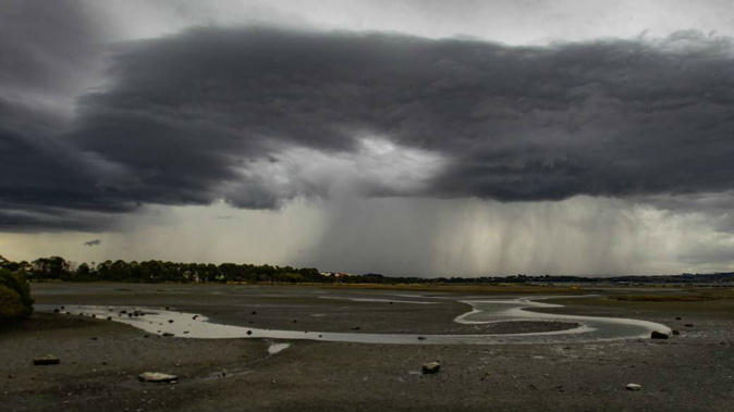
However, western areas would see periods of rain, thunderstorms and potentially small hail.
Auckland was forecast some isolated showers until midday, then occasional rain with hail and possible thunderstorms, before easing at night.
MetService meteorologist Stephen Glassey said it was already raining in parts of Waikato, which would see most of the rain today.
"However, we expect it to get across all other parts of the upper North Island, and lesser amounts further south."
Light winds again for much of NZ tomorrow, although northerlies start to pick up in the far south. Look out for some mist and fog for inland parts tonight. ^TA pic.twitter.com/MCRjAoBZVC
— MetService (@MetService) July 18, 2018
During the afternoon and evening, two fronts were expected to move eastwards across the North Island with bands of rain and possible thunderstorms.
There was a moderate risk of thunderstorms about Auckland, the Hauraki Gulf, Waikato, western Waitomo and possibly northern Taranaki during the afternoon or early evening.
These thunderstorms would be accompanied by localised heavy rain or 10-20mm/h and small hail.
The South Island would escape most of the wet weather today, with just some showers in the west and north.
A weak front brings a few showers into western parts tomorrow, but most eastern and central parts stay dry. Find out the full details for your area on https://t.co/Yjbq0jxdqz . ^TA pic.twitter.com/neXcwHlUy3
— MetService (@MetService) July 18, 2018
Temperatures overnight were relatively warm, but Hamilton and Christchurch both had some thick fog in the early hours.
Tomorrow the front would move off the North Island and weaken, bringing more settled weather.
Saturday was looking like the day of the weekend for the North Island, with mostly fine and settled weather, before a front arrived from the South Island on Sunday bringing rain and showers to most places.
On Friday a moist northerly flow would strengthen over the South Island ahead of the front arriving Saturday.
On Friday and Saturday there was potential for severe northwest gales over parts of Fiordland, Southland and Otago.
On Saturday these gales could affect the Canterbury High Country, coastal parts of Canterbury, and Marlborough, Wellington and Wairarapa.
There was also a high chance of heavy rain Saturday about Fiordland and Westland, and also over Buller and northwest Nelson.
On Sunday the front should weaken over the North Island, but cold westerlies could briefly bring snow showers to 500m in the lower South Island.
There was potential for periods of rain in the North Island on Sunday, mostly concentrated from Taranaki through the high country to Taupō, Glassey said.
On Monday, a ridge of high pressure was expected to move onto the South Island, bringing more settled weather.
Today's weather
Fine at first then occasional rain from afternoon, clearing at night as northwest turns southwest. 18C high, 7C overnight.
Isolated showers until midday, then occasional rain with hail and possible thunderstorms, easing at night as northwest tends southwest. 16C high, 9C overnight.
Occasional rain, possibly heavy with hail after midday, easing at night. Northerlies dying out evening. 14C high, 6C overnight.
Occasional rain developing in the morning, easing overnight. Light winds. 15C high, 7C overnight.
New Plymouth Cloud increasing. Occasional rain from afternoon, easing at night. Northerlies turning westerly evening. 14C high, 7C overnight.
Napier Fine at first. Cloudy periods from afternoon. Light winds. 15C high, 3C overnight.
Wellington Mainly fine, but a few showers in the north from afternoon. Northerlies. 13C high, 9C overnight.
Nelson Fine at first, then partly cloudy and a shower or two. Northerly breezes. 13C high, 2C overnight.
Christchurch Fine with northerlies. 12C high, 0C overnight.
Dunedin Fine. Northerlies dying out late afternoon. 13C high, 5C overnight.
Take your Radio, Podcasts and Music with you